Rangeland Hydrology and Erosion Model Web Tool
About RHEM
Core Engine
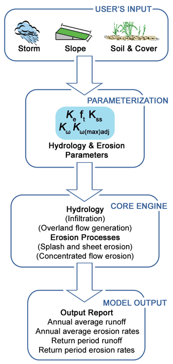
The RHEM core engine development was initiated in 2003. The current version of RHEM is a single storm, hillslope scale model that requires user input information (Figure 1) on:
- Storm
- Soil and Cover
- Slope
- Infiltration/runoff/erosion parameters
Figure 1. A flow chart of the RHEM erosion prediction procedure

Current Capabilities
RHEM is currently a single storm runoff and erosion computer model. Parameter estimation equations have been developed based on the measured rangeland erosion plot data for the two primary erodibility and infiltration parameters (Kss and Ke). Parameter estimation for other input parameters, including concentrated flow detachment, are currently under development. The parameter estimation procedures for Kss and Ke are grouped according to dominant plant forms of sod-grass, bunch-grass, shrubs, and forbs with a different set of estimation equations for each grouping. Hence currently, the model may be parameterized and executed for undisturbed rangeland conditions.
Additional Capabilities
- Parameter estimation procedures for the remaining infiltration, runoff, and erosion parameters, which include concentrated flow erodibilities and hydraulic friction factors capable of representing infiltration, runoff, and erosion on undisturbed rangeland hillslopes.
- Procedures have been developed to specifically execute model predictions for NRI data, such that a user may estimate runoff and erosion rates for single storms at NRI sites.
- A risk assessment methodology has been developed that calculates the risk of various sized erosion events occurring at a site of interest in its current or assumed condition.
- The risk assessment methodology using return frequency storm values will be further refined to calculate the risk of various sized erosion events occurring at a site of interest in its current or assumed condition.
- Update has been applied with the capacity to account for the effect of saline soils on erosion and to provide estimates of salt loads associated with runoff and erosion events.
- Implemention of the CLIGrid feature enabling RHEM to use storm inputs from pre-ran CLIGEN scenario runs for CONUS using 4km PRISM data.
- The international climate station listing has been expanded to include multiple countries.
Capabilities In Progress
- Expansion of the international climate station listing to include Africa and South America.
- Juniper (woodlands) cover type integration.
- Integrate fire and vegetation disturbance applications.
RHEM Updates Workflow

Built with:
